Google Maps is an indispensable tool for navigation, offering a plethora of features and icons designed to make your travel and exploration efficient. While these icons are essential, understanding their meanings can sometimes be challenging. This guide provides a comprehensive breakdown of Google Maps icons, ensuring you make the most out of this navigation tool.
Icons on the Home Screen
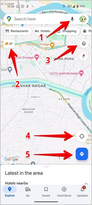
The home screen of Google Maps is your control center, packed with icons to simplify navigation and provide essential information at a glance.
Common Home Screen Icons:
- Microphone Icon: Use this for voice search when you’re on the go and prefer not to type.
- Temperature Icon: Displays the current temperature at your location, helping you plan for weather conditions.
- Box and Down Arrow: Customize your map view by switching between default, satellite, or terrain modes. You can also toggle features like public transit or live traffic.
- Compass Icon: Quickly navigate to your current location with one tap.
- Blue Right Arrow: Set a route between two locations, with your current location as the default starting point.
Icons on the New Journey Screen
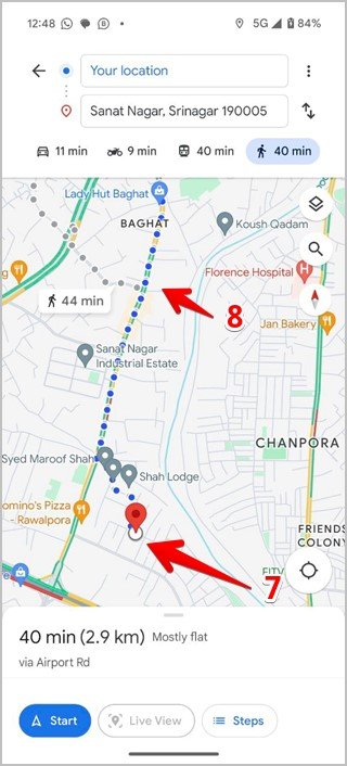
When planning a new journey, Google Maps introduces additional icons to refine your route and mode of transportation.
Journey Planning Icons:
- Two Arrows: Swap the start and destination points with ease.
- Car Icon: Select driving directions, ideal for road trips or daily commutes.
- Bike Icon: Plan routes suitable for cycling.
- Train Icon: Access public transportation options with schedules and station details.
- Walking Person Icon: Map out pedestrian-friendly routes.
- Clock Icon: Revisit previously searched locations or routes for convenience.


Destination-Specific Icons:
- Red Pin Icon: Marks your destination or a specific point of interest.
- Path Shown by Small Circles: Represents walking paths, often seen in parks or pedestrian zones.
Icons on the Ongoing Journey Screen
During an active journey, Google Maps provides tools for real-time adjustments and issue reporting.
Navigation Tools:
- Colored Microphone Icon: Activate Google Assistant for hands-free tasks like making calls or playing music.
- Search Icon: Look for points of interest along your route, such as gas stations or restaurants.
- Speaker Icon: Manage voice navigation settings to mute, unmute, or adjust volume.
- Compass Icon: The red part always points north, keeping you oriented.
- Chat Bubble with Plus Icon: Report road incidents, construction, or lane closures.
- X Icon: End navigation with one tap.
- Forked Path Icon: View the entire route to your destination for a comprehensive overview.

Traffic Condition Symbols
Google Maps uses real-time traffic data to keep you informed about road conditions. These are indicated by color-coded roads:
- Green Roads: Smooth traffic flow with no delays.
- Yellow/Orange Roads: Moderate congestion or light traffic.
- Red Roads: Severe congestion or traffic jams.

Icons Representing Various Places in Google Maps
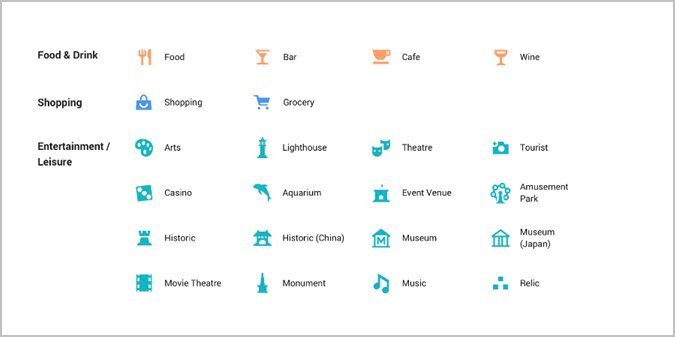
Google Maps categorizes locations using intuitive icons and colors. These help users identify places quickly.
Personal Icons:
- Person: Represents a contact’s place.
- House: Indicates your home address.
- Bag: Marks your workplace.
- Calendar: Denotes an appointment or event location.
- Heart: Shows a place you’ve favorited.
- Green Flag: Highlights a location you wish to visit.
Road Condition Icons:
- Man with a Shovel: Signals ongoing road construction.
- Dash Icon: Indicates a closed road or no-entry zone.
- Yellow Exclamation Mark: Warns of potential road closures.
- Red Car with Half-Star: Suggests accidents or hazards on the road.

Food & Shopping Icons:
- Knife and Fork: Marks restaurants or food spots.
- Glass: Represents bars or wine cellars.
- Cup and Saucer: Identifies cafes or coffee shops.
- Shopping Bag: Highlights shopping centers or stores.
- Trolley: Points to grocery stores.
Entertainment & Outdoor Icons:
- Color Palette: Indicates art galleries.
- Lighthouse: Represents lighthouses.
- Camera: Marks tourist spots or scenic views.
- Swing: Denotes amusement parks.
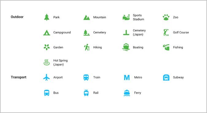
- Tree: Represents parks.
- Mountain: Identifies hills or mountains.
Transport & Service Icons:
- Aeroplane: Denotes airports.
- Train Icon: Marks train stations.
- P: Highlights parking areas.
- Gas Pump: Represents petrol or gas stations.
- ATM: Points to ATMs.
Other Icons on the Map
Google Maps includes several other helpful symbols for enhanced navigation and exploration.
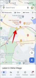
- Yellow Star in Map Pin: Represents a saved or starred location.
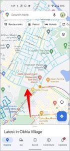
- Blue Dotted Path: Appears in Street View to show real images of roads.
Meaning of Color-Coded Icons
Google Maps groups similar icons by color for easier recognition:
- Orange: Food and drink spots.
- Blue: Shopping and transportation hubs.
- Red-Pink: Health-related places.

- Teal: Entertainment and leisure.
- Green: Outdoor activities.
- Purple: Services and utilities.
Conclusion
Mastering Google Maps’ icons and symbols can dramatically improve your navigation experience. Whether you’re exploring new destinations, managing daily commutes, or checking live traffic updates, these icons act as your visual guide. Familiarizing yourself with their meanings will help you use Google Maps with confidence and efficiency.
Frequently Asked Questions (FAQs)
1. How do I change map view types in Google Maps?
Tap the box and down arrow icon to switch between default, satellite, or terrain views.
2. How can I find traffic information on Google Maps?
Traffic conditions are displayed via color-coded roads: green for clear, yellow/orange for light congestion, and red for heavy traffic.
3. What does the red pin on Google Maps mean?
The red pin marks a destination or saved location on the map.
4. How do I report road conditions on Google Maps?
Tap the chat bubble with a plus icon to report issues like accidents, construction, or road closures.
5. Can I save places on Google Maps?
Yes, you can save places by tapping the star icon or marking them as favorites for quick access.

